
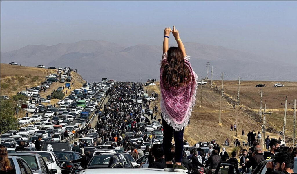
For decades, Kurdish cities in Iran have been centers of resistance against the Islamic Republic, from the mass demonstrations that followed the 1979 revolution to the Woman, Life, Freedom uprising of 2022, which spread across Iran and beyond, and the countrywide protests of January 2026. These successive uprisings have been met with violent repression, with Kurdish human rights organizations documenting the killings, injuries, and disappearances of protesters. Yet while these violations have been extensively documented, the spatial preparation behind the crackdowns remains largely overlooked. Far less attention has been paid to how Iranian authorities use urban planning and public facilities to carry out repression in Rojhelat (the Kurdish region of Iran).
My interest in this overlooked dimension of state violence emerged from my double life as an urban planner and a protester. For nearly a decade, I worked with urban planning consultancies in Iran, including three years for the Ministry of Urban Development, preparing master plans, detailed development plans, traffic circulation plans, and land subdivision schemes. I witnessed how these plans underwent security review by the Islamic Revolutionary Guard Corps (IRGC) before final approval. Meanwhile, as a protester, I experienced first-hand how streets, intersections, and public spaces shaped demonstrators’ movements and security force deployments. These two experiences led me to investigate the relationship between urban development and state repression.
This question became the basis of a research project I initiated as a postdoctoral researcher at Yale University in collaboration with University College London (UCL). So far, more than 500 people with first-hand experience of protesting in five Kurdish cities—Mariwan, Sine (Sanandaj), Javanrud, Kirmaşan (Kermanshah), and Saqqez—have mapped their experiences of demonstrations spanning the last five decades. Using interactive maps, participants identify where protests took place, the routes demonstrators followed, where security forces were deployed, and where crackdowns occurred. These accounts are examined alongside urban plans and satellite imagery to investigate how urban space has shaped repression and how the physical environment has changed between successive uprisings.
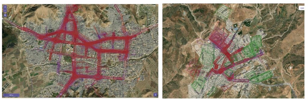
While participatory mapping continues in other Kurdish cities, the findings from Mariwan already reveal a pattern that official land-use maps do not show. Participants identified not only military bases but also civilian and commercial infrastructure as sites used by security forces during protests. Reports of deployments in civilian and commercial facilities outnumber those in designated military and Basij (paramilitary) sites by nearly six to one. Buildings intended for everyday urban life—a place to study, to bank, or to park a car—reappear in protesters’ accounts as positions from which security forces monitored demonstrations, deployed against crowds, and, in some cases, opened fire.
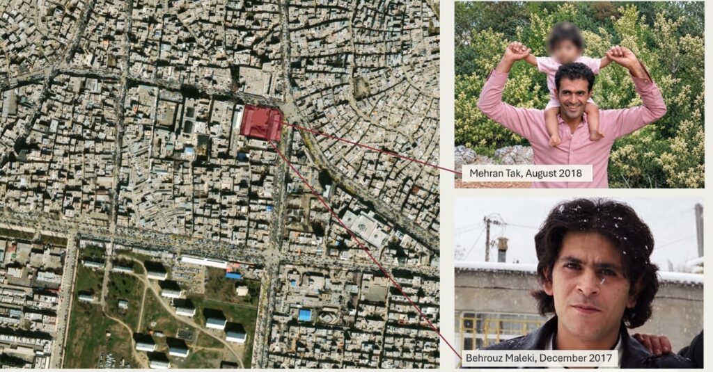
During the Bloody November protests of 2019, the tobacco company compound in central Mariwan became one such site. Located near one of the city’s main protest corridors, the facility was used by security forces during the crackdown. Participants in the research described armed personnel taking positions on its rooftop and opening fire on demonstrators in the streets below. They identified the rooftop as the source of the gunfire that killed two protesters, Mehran Tak and Behrouz Maleki. The compound’s location allowed security forces to operate above a major protest route, turning a facility tied to the city’s civilian economy into a position from which lethal force was deployed.
The tobacco compound illustrates how an existing civilian facility can be used during a crackdown. But the study also reveals a longer process: how the regime’s infrastructure of repression changes between successive uprisings. In Mariwan, protesters have repeatedly returned to the same streets and squares, while the security infrastructure surrounding these gathering places has evolved. Some facilities were temporarily occupied during demonstrations; others underwent physical transformations that established a permanent security presence. Daraei Square in Mariwan offers a particularly revealing example. Long associated with Newroz celebrations among residents of surrounding lower-income neighborhoods, the square became the site of a significant transformation around 2020, when a Basij militia post was established at the site of a former local clinic.
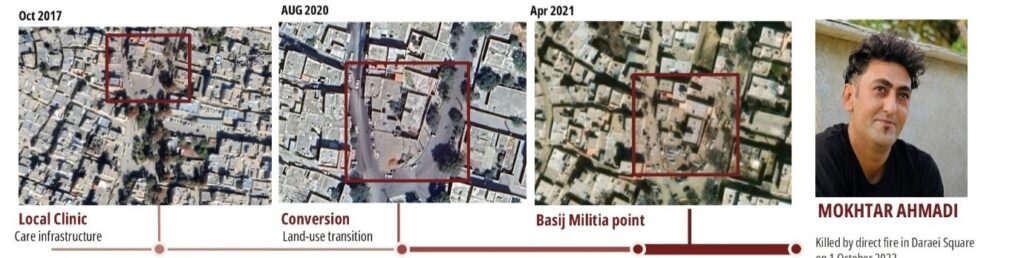
Two years later, during the 2022 Jin, Jiyan, Azadî uprising, the newly established Basij post reportedly became a firing position. Participants in our research described armed personnel shooting from its rooftop towards demonstrators around Daraei Square. They identified this position as the source of the gunfire that killed Mokhtar Ahmadi, who was shot in the neck during the crackdown. While Kurdish human rights organizations documented his killing, the identification of the rooftop as the firing position comes from protesters’ mapped accounts. The transformation of a former civilian service site into a security installation overlooking a longstanding gathering place illustrates how changes to the built environment can expand the state’s capacity for repression.
The change becomes clearer when successive uprisings are compared. In Mariwan, participants recalling the demonstrations of 1999 described security forces arriving from outside the city and withdrawing when the protests ended. Accounts from 2019 and 2022 reveal a different pattern, with security forces operating from civilian buildings and increasingly from permanent installations within the city itself. These accounts show a shift from temporary deployments towards a security presence embedded in the urban environment, with facilities that remain in place long after demonstrations have ended.
The relationship between urban development and repression extends beyond individual buildings. On a map of Sine (Sanandaj), the Imam Ali military base appears peripheral—situated on the city’s southeastern outskirts, beside the airport and far from the city center. The road network tells a different story. Pasdaran Boulevard, the Behesht Mohammadi ring road, and other major routes connect the base to central neighborhoods, major intersections, and locations where protests repeatedly occur. What appears geographically isolated is therefore strategically connected, occupying an important position within the city’s street network. By comparing these connections with protesters’ mapped experiences, we are examining how the configuration of streets may facilitate security-force deployments and enable authorities to control movement along key protest corridors.
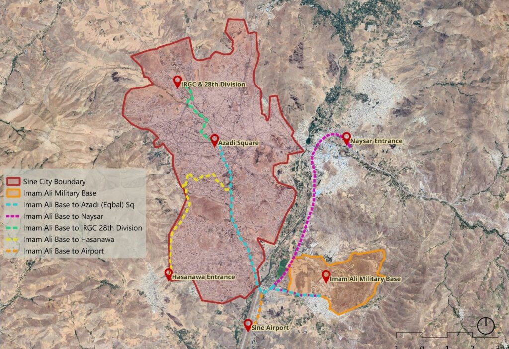
Land use is only the first layer of this investigation. In Mariwan, protesters’ mapped accounts have been compared with the official functions of buildings and public spaces to identify civilian infrastructure used during crackdowns. The analysis is now being extended to property ownership, block sizes, street networks, CCTV camera locations, and historical urban plans. Examining these different layers may help establish how security forces gained access to particular locations, when their functions changed, and which institutions were involved. It may also help distinguish buildings and streets used opportunistically during protests from those whose development or transformation reflected longer-term security priorities.
By the time protesters returned to Daraei Square in 2022, the clinic that once served the surrounding neighborhood had been replaced by a Basij post. Satellite imagery reveals the physical transformation, but not the decisions behind it: Who authorized the change and for what purpose? Similar questions remain about civilian buildings used during crackdowns and the roads connecting military installations to protest locations elsewhere in Rojhelat. Some answers may lie in municipal archives, planning documents, old photographs, and the memories of residents, protesters, and urban planners who witnessed these changes. I hope those with such records or first-hand knowledge will share them as this investigation continues. After decades of uprisings, much has been documented about what happened when protesters entered the streets. But another history remains largely untold: what had already been done to those streets before the protesters arrived.
- Soran Mansournia is a postdoctoral researcher at Yale University and a Middle East Minorities Institute Council of Experts member.
The views, thoughts, and opinions expressed in this article belong solely to the author and do not necessarily reflect the official policy, position, or views of the Middle East Minorities Institute, its leadership, or its affiliates.